Home . About . GPS . Downloads . Business . Partners . Contact . Family . AVL . Links . History . AsOnTV . Snoopy
 If you stumbled on this page by accident, and need "the bigger picture", see Snoopy's front page:
GPS Guided Trans-Atlantic Robot Boat.
If you stumbled on this page by accident, and need "the bigger picture", see Snoopy's front page:
GPS Guided Trans-Atlantic Robot Boat.
This page includes:
1. this Introduction
2. Story in pictures.
3. Conclusions.
4. More information.
5. What we said on the front page before the launch.
The launch at 0850 from Barton-on-Sea, on Saturday 6th September 2014: FLAT surf but almost no wind: Dick on right, filming ! :-)

Here is what was put up late Saturday night, 6th September 2014, along with first Video covering the morning launch until late Saturday night. :
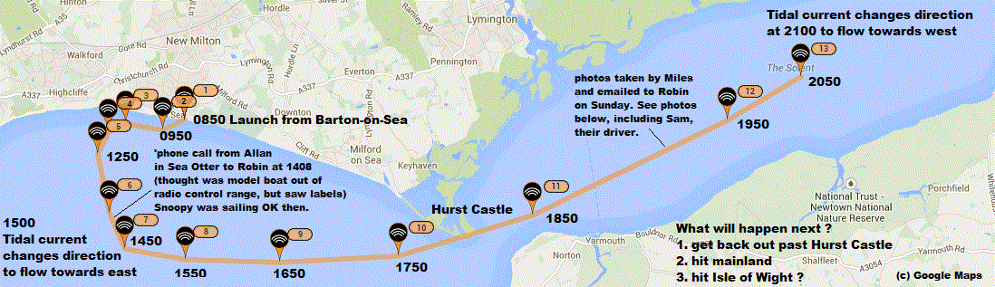
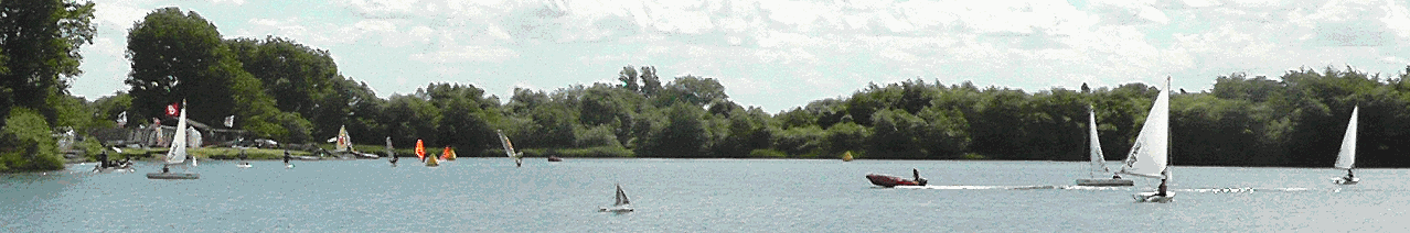
... Snoopy approaching sailing boats when he was sailing well, between about 1pm and 3pm: maybe 1.5 miles from us ? One was Sea Otter ? Thanks Allan ! :-)

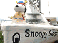
... Saturday evening, we watched Snoopy being dragged by the tide, into the Solent, on the SPOT tracker. What happened later is in the pictures below, but first, here are pictures from Miles, taken at about 1930 (730pm). I was delighted to get his first email on Sunday, with those pictures of Snoopy. His email said, "Last night about 730 off Yarmouth, looking good in no wind and about to be sluiced into the Channel on the tide. Good luck. Miles". Miles, with wife Susie, and kids Sam and Daisy, were on their way back from Yarmouth to Keyhaven, when they spotted Snoopy's boat, and went to investigate. That's Sam, the boat driver ! Thanks Miles :-)

... and here is where Snoopy was, early Sunday 7th September 2014. Dick got on the early Isle of Wight Ferry, and was in contact with Roger on the Island.

... Snoopy at 10am Sunday 7th September 2014. Being carried up footpath by Dick and Roger ?

... by 1230 Sunday, Robin gets news, photos, and video from Dick, on his way home with Snoopy for repairs. You can see where Snoopy is now, by clicking here.

Snoopy and Dick's ETA in Sunninghill is before 2pm and the next SPOT position report.
Here is Dick and Snoopy, after safe arrival in Sunninghill. Well Done Dick !

Good Decision by Dick to bring Snoopy home: landing on beach had broken* the keel and stripped the gear in rudder servo ! * the original wood of the wooden keel had become rotten. Snoopy will sail again on this boat this year, but not until it is repaired, and both Robin and Dick have taken their long-suffering wives on holidays. Earliest next attempt will not be before late October. Next year's boat has already had it's maiden sail, but that is many months from being ready. This one can try again this year ! But before we do, we need to think "from where ?".
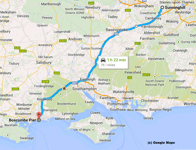
"Why on earth do you keep launching Snoopy from Barton-on-Sea ?" People often suggest places such as the south coast of the Isle of Wight, and my Q and A Page has answered questions like this for some time. I've added a footnote , mentioning that next time, we may try launching from a bit further west, such as Highcliffe ( 3 miles, and where we watched Snoopy from, and I ate ice-cream ) or even near Boscombe Pier, just 8 miles, where Dick hired a kayak for one of the March 2013 attempts. Dick suggested that we try another place along that same stretch of coast, and June (my wife) just suggested Boscombe to me, because she remembers it having a nice sandy beach. I remember it being very easy access, across the sand to the water, and it should be possible to launch well away from the pier. The nice surprise is that the 80 miles from home only takes five more minutes than to Barton-on-Sea. I remember Dick suggesting, when we took his kayak back, that we might try a launch where Snoopy is dropped from the end of the pier ! Click on the map, on the right, to see the bigger version and read the details.
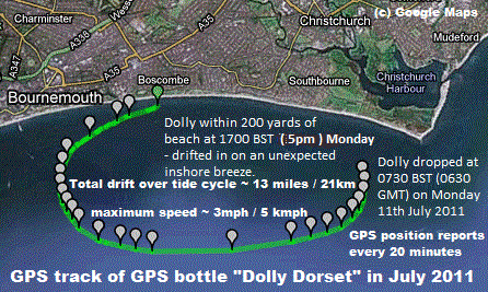 Boscombe is where GPS Bottle "Dolly Dorset" landed, in 2011, to party with Liz, before being returned to BBC Radio Solent.
This year we launched early in the morning, to catch the tidal current as it started to to flow to the west.
This tactic, suggested by Dick, may have worked if we had a good breeze, instead of close to still wind conditions.
We will probably use the same tactic again, wherever we launch from, and it will be useful to know even more
about how the boat will behave, in different conditions of wind and tide - and what the tide will do.
Boscombe is where GPS Bottle "Dolly Dorset" landed, in 2011, to party with Liz, before being returned to BBC Radio Solent.
This year we launched early in the morning, to catch the tidal current as it started to to flow to the west.
This tactic, suggested by Dick, may have worked if we had a good breeze, instead of close to still wind conditions.
We will probably use the same tactic again, wherever we launch from, and it will be useful to know even more
about how the boat will behave, in different conditions of wind and tide - and what the tide will do.
This has made us look again, prompted partly by "local knowledge" from sailors who have contacted us, at what the tide actually does, compared with what we have in the H.O. charts and TotalTide computer model. It turns out that the track of GPS bottle Dolly Doreset, on the left, has become invaluable. It seems that the tide actual flows at nearer 1.5 x the speed of that expected from the computer model. e.g. 3 mph instead of 2 mph. The distance the boat might be carried is therefore greater. e.g. Dolly Dorset, without sails or autopilot, travelled a maximum of 13 miles ( 11.4 NM or 21 km ) in 2011. The "More Information" below includes a Google Earth KML file, so you can analyse the GPS track of Snoopy's last attempt. This again confirms that the actual speed of drift was about 1.5 x that in the charts. The tide is also much faster through that "pinch point" near Hurst Castle. If you want to know more about the GPS Bottles, including Dolly Dorset, click on the GPS plot on the left, or visit the BBC Bottle Page.
 The other important question is "how will the boat behave ?". We know that the small sails, compared with the hull,
chosen to survive strong winds at sea, will give the boat a maximum speed downwind, in a stiff breeze, of about 3 knots,
and cross-wind, of maybe about 2 knots. The boats speed will be in the ballpark of 10% of the wind speed, cross wind,
and 15% downwind. e.g. only 0.5 knots south, westerly wind of 5 mph, and little tidal current.
There are numerous GPS plots on our earlier
Blog2 page, such as that on the right: click on it to read the details.
The other important question is "how will the boat behave ?". We know that the small sails, compared with the hull,
chosen to survive strong winds at sea, will give the boat a maximum speed downwind, in a stiff breeze, of about 3 knots,
and cross-wind, of maybe about 2 knots. The boats speed will be in the ballpark of 10% of the wind speed, cross wind,
and 15% downwind. e.g. only 0.5 knots south, westerly wind of 5 mph, and little tidal current.
There are numerous GPS plots on our earlier
Blog2 page, such as that on the right: click on it to read the details.
If the boat is sailing with very little tidal current, such as when the tide is turning, or near the shore, it will have a speed similar to as on Bray Lake. However, if there is a sideways current, the boat will be sailing at an angle, to aim for it's destination waypoint. If the tidal current is sufficiently fast, compared with the sailing speed, the autopilot will become "confused", and may result in the boat simply have full rudder, turn circles, and drift with the tide. Examination of SPOT position reports, and tide speed, for earlier attempts such as 2012, 2013 and 2014 attempts may help us quantify when Snoopy will "sail straight", "drift with the tide" or some mix of the two.
 There was a snag with launching too far west, or at a time when the tide may carry Snoopy west, past Boscombe Pier
- the autopilot would start to steer west, towards the "Prawl" waypoint, and probably go aground between Bournmouth and Swanage !
The details of this first appeared in our
Blog giving details of Snoopy's repairs and tests leading to the next attempt.
There was a snag with launching too far west, or at a time when the tide may carry Snoopy west, past Boscombe Pier
- the autopilot would start to steer west, towards the "Prawl" waypoint, and probably go aground between Bournmouth and Swanage !
The details of this first appeared in our
Blog giving details of Snoopy's repairs and tests leading to the next attempt.
We have made a small change to the autopilot software, so that it does not switch to steering west, towards "Prawle", until it is past the headland near Swanage. This gives us enormous scope to choose the location of launch, and time - to exploit the tidal current, and avoid landing on the Isle of Wight again !
The blog, also reached by clicking on the map on the right, gives the nitty-gritty - too detailed for most readers - of work, day by day, in mending Boat 10, including replacing the broken keel and changing the software. If you scroll down towards the end of it, you will see how far we've got, in re-testing the boat to prepare it for the next attempt this year.
Here is more information about the September 2014 Attempt, as it becomes available. Thanks to Colin, at Aberystwyth University, who administers the Microtransat web site and rules, you can examine Snoopy's SPOT position reports with Google Earth. e.g. below is Snoopy's position at the time of launch, near the rocks seen on our videos. If you have Google Earth on your computer, you should be able to open Snoopy's September Attempt KML file. Robin extracted this from the Microtransat Tracking Page. Thanks Colin :-)

Thanks to Chris in Canada, we now have the detailed plot below, recorded by Snoopy's I-GotU GPS logger: every 12 minutes.
Thanks Chris ! Colin has now added it. Thanks Colin !
You can see the
I-GotU plot in Google Earth extracted with Notepad from what is now on Microsat Tracking Page above.
It should be clearer, with less labels.

This is what we said ...
 Snoopy has been ready for this year's Atlantic attempt for weeks,
doing 24/7 reliability testing on Bray Lake, while waiting for a "weather launch window".
This Saturday, and the following days, may be the best opportunity we get this year.
The lack of wind risks Snoopy not sailing fast enough to overcome the tide,
but - if he does get away from the coast - he may have a following wind
for that difficult leg towards Ireland. An early morning start means
more hours with an offshore breeze, and a few hours of the tide pulling him westward,
away from the Isle of Wight.
The SPOT Map will show if we are on schedule, and gives a new position
every hour, at about 45 minutes past. e.g. when we leave home in Sunninghill,
you will see us on our way, or that position report will be delayed,
or not appear, because the SPOT tracker is inside the car.
When we get to
Barton-on-Sea
, you should see our position on the beach, before we launch.
See "Snoopy's route ... How long will it take ?" below, for our best guess on when things happen. e.g. Launch at 0850 ?
Snoopy has been ready for this year's Atlantic attempt for weeks,
doing 24/7 reliability testing on Bray Lake, while waiting for a "weather launch window".
This Saturday, and the following days, may be the best opportunity we get this year.
The lack of wind risks Snoopy not sailing fast enough to overcome the tide,
but - if he does get away from the coast - he may have a following wind
for that difficult leg towards Ireland. An early morning start means
more hours with an offshore breeze, and a few hours of the tide pulling him westward,
away from the Isle of Wight.
The SPOT Map will show if we are on schedule, and gives a new position
every hour, at about 45 minutes past. e.g. when we leave home in Sunninghill,
you will see us on our way, or that position report will be delayed,
or not appear, because the SPOT tracker is inside the car.
When we get to
Barton-on-Sea
, you should see our position on the beach, before we launch.
See "Snoopy's route ... How long will it take ?" below, for our best guess on when things happen. e.g. Launch at 0850 ?
In March, the boat had a major rebuild, including modified keel, different rudder, a better waterproof "lunchbox", new rig, and coats of anti-fouling paint. We can justifiably call this "Snoopy Sloop 10", despite it being a rebuild of boat 9, rescued after last year's attempt. After months of testing on Bray Lake, it now seems last year's failure was due to something as simple as a screw coming loose on the rudder linkage, or some unkown combination of that and sailing "balance" of the boat. We've made minor modifications to the boat, such as moving the mast, and put Loctite on that screw, that came loose, allowing the rudder to shift ! :-)
Snoopy needs a day with suitable conditions for launch, to sail south to about 15 miles off the coast, before heading west, almost 300 miles. This stretch to south of Ireland, was always going to be tough, so we want close to a week of favourable wind, from the East or North, rather than from West or South. Play the June 2014 video of Snoopy's Robot Boat for 2014 Microtransat for the latest video and the big picture. e.g. details of this year's boat and lessons learned.
 See our
Q&A
page. e.g. why launch from Barton-on-Sea ?
The blog
and
blog1
pages
have the nitty-gritty of progress, towards Snoopy's next attempt,
and the
design page
has detail for those interested.
The section "a typical visit to Bray Lake ...", on this page, below, may also be of interest.
For his last attempt on the Atlantic, see the details:
October 2013 Atlantic Attempt, including Dick's story
of the rescue.
Watch the
Video of Snoopy's October 2013 Atlantic Attempt.
Snoopy tried the Atlantic twice in March 2013, when we had an excellent "weather window" - but for the surf !
See our
Q&A
page. e.g. why launch from Barton-on-Sea ?
The blog
and
blog1
pages
have the nitty-gritty of progress, towards Snoopy's next attempt,
and the
design page
has detail for those interested.
The section "a typical visit to Bray Lake ...", on this page, below, may also be of interest.
For his last attempt on the Atlantic, see the details:
October 2013 Atlantic Attempt, including Dick's story
of the rescue.
Watch the
Video of Snoopy's October 2013 Atlantic Attempt.
Snoopy tried the Atlantic twice in March 2013, when we had an excellent "weather window" - but for the surf !
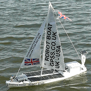
 Snoopy has boat10 for his attempt at the Atlantic this year. On the left is the boat on 24/7 test, without additional
test equipment such as Pocket PC, Mobius deck camera, and FM transmitter. In fact: just as intended for the Atlantic.
Click on the picture for a bigger copy.
Snoopy has boat10 for his attempt at the Atlantic this year. On the left is the boat on 24/7 test, without additional
test equipment such as Pocket PC, Mobius deck camera, and FM transmitter. In fact: just as intended for the Atlantic.
Click on the picture for a bigger copy.
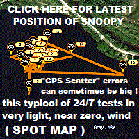
We plan to launch him again from Barton-on-Sea as soon as we can, and the wind and waves allows us. We need a dry weekend day, with Winds expected from the North or East for several days, ideally a week. The launch day should have waves smaller than 1 ft, or FLAT conditions, forecast on magicseaweed.com . You can see where Snoopy is now, by clicking on his SPOT map , updated every hour - on Bray Lake or at home, being repaired or about to travel to the coast ! :-)
 Before making an Atlantic attempt, Snoopy has several weeks of "24/7 tests", to ensure all the boat is reliable.
Snoopy sailed over 5,000 miles on Bray Lake in 2012, and has sailed a lot further since then !
If the wind drops
to below about 1mph - as often happens at night -
Snoopy "goes for a wander". If he gets stuck
near the shore, Robin goes over to push Snoopy out again.
While Snoopy prepares for the Atlantic, Robin sometimes "plays" on Bray Lake with possible improvements
for boats launched in future years.
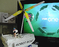
That's Snoopy on the right, watching Telly, sat on his
Windmill Boat :-)
See the
Compass and
Software
pages for experimental work in progress on electronics and software for next year's boat,
and related new videos.
Before making an Atlantic attempt, Snoopy has several weeks of "24/7 tests", to ensure all the boat is reliable.
Snoopy sailed over 5,000 miles on Bray Lake in 2012, and has sailed a lot further since then !
If the wind drops
to below about 1mph - as often happens at night -
Snoopy "goes for a wander". If he gets stuck
near the shore, Robin goes over to push Snoopy out again.
While Snoopy prepares for the Atlantic, Robin sometimes "plays" on Bray Lake with possible improvements
for boats launched in future years.
That's Snoopy on the right, watching Telly, sat on his
Windmill Boat :-)
See the
Compass and
Software
pages for experimental work in progress on electronics and software for next year's boat,
and related new videos.
Want to cheer Snoopy on ? Be prepared to sing "Rule Britania!", and bring a flag to wave :-)
This is all academic if Snoopy only survives a few minutes, hours, or even days, but here is my best guess on how long it might take to travel the 5300 miles to the USA. Maybe he might sail at up to 1.5 mph - if he gets away from the UK shore. The wind needs to be kind on that difficult stretch west, to 7.5W, south of Ireland. When the wind changes to it's normal direction, from the south-west, it will be VERY slow ! The wind is expected to be very light, of only 3 mph on Saturday, so Snoopy might struggle to sail at even 0.3 mph. Hence the pessimistic guess below of when he might reach his first "Channel" waypoint, 15 miles out. I'll keep this section updated, after we launch, and while we are able to track Snoopy, to see how well he progresses, and at what speed, the latest wind predictions, etc.

 As mentioned earlier, Snoopy may only survive a few minutes or hours, but if he DOES reach that first "Channel" waypoint,
about 15 miles due south from Barton-on-Sea, this is where he plans to sail next.
As mentioned earlier, Snoopy may only survive a few minutes or hours, but if he DOES reach that first "Channel" waypoint,
about 15 miles due south from Barton-on-Sea, this is where he plans to sail next.
His autopilot software has not been changed since January 2013, and is programmed to head for a position on what was the old Microtransat Start Line, at 7.5 degrees West. The intermediate waypoints, south of Prawle Point and The Lizard, are intended to reduce the risk of him "bumping into the shore" due to inaccuracy of keeping his course.
If he succeeds in eventually crossing the 7.5W line, he should then head south west, to his next waypoint east of The Azores. This should mean he would cross the 2014 Microtransat Start Line at about 47N 11W. In the unlikely event that Snoopy gets this far, Robin will publish more detail on the route ahead: not much risk of that ! :-)
© 1991-2014 Robin Lovelock. Please credit www.gpss.co.uk if you use material from any of these pages. Thankyou.