Home . About . GPS . Downloads . Business . Partners . Contact . Family . AVL . Links . History . AsOnTV . Forum
 from Robin:
We have now completed most of our story, and some supporting information, on this page. Newspapers have started to contact me,
and I've just added links to some higher resolution pictures at the very bottom. Use of this page saves us all time
with private emails and the 'phone ;-)
from Robin:
We have now completed most of our story, and some supporting information, on this page. Newspapers have started to contact me,
and I've just added links to some higher resolution pictures at the very bottom. Use of this page saves us all time
with private emails and the 'phone ;-)
You can now watch our 10 minute Video of Snoopy's October 2013 Atlantic Attempt.
You may want to bookmark this page and check for the updates, still in progress.
If you stumbled on this page by accident, and need "the bigger picture", see GPS Guided Trans-Atlantic Robot Boat which usually holds the latest news.
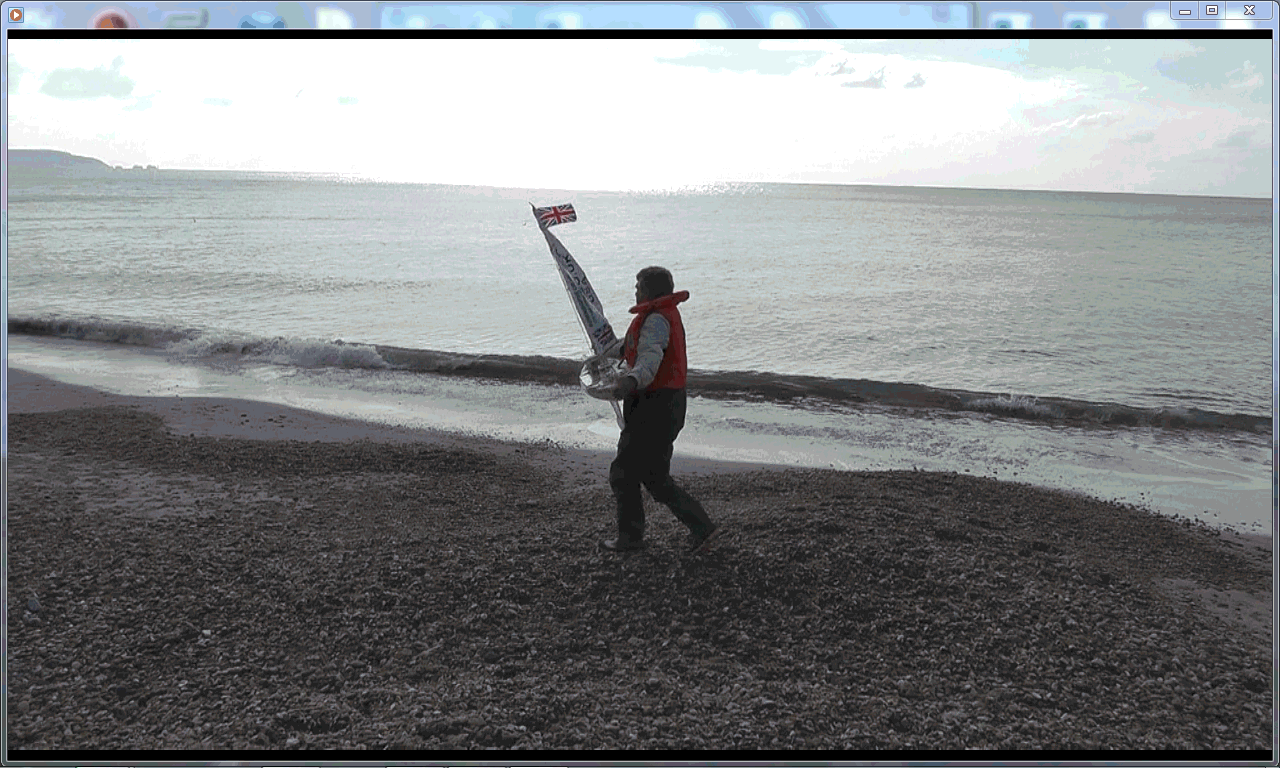
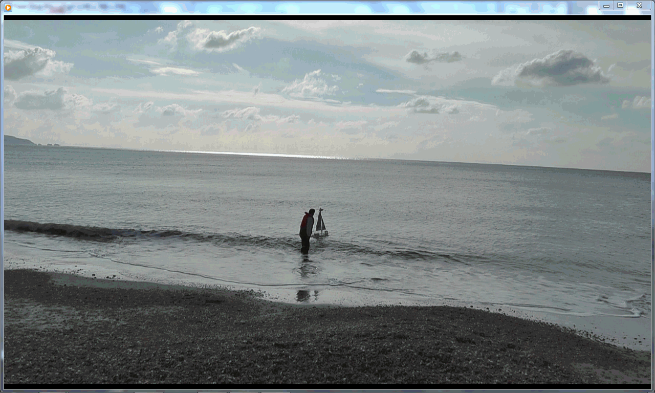
Below you see photographer friend Peter, Roz from BBC, and Robin launching Snoopy...
 Snoopy takes the "Scenic Route" ...


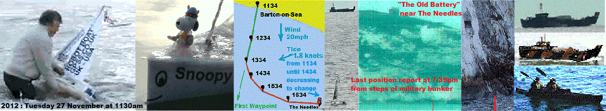
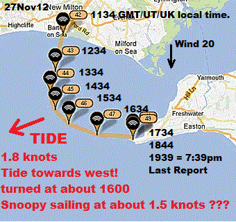
Snoopy was launched at 1215pm on Friday 11th October in FLAT sea conditions, just as predicted on MagicSeaweed. We did not have to suffer the problems experienced in March, of "getting past the surf". Conditions looked perfect, including a stiff offshore breeze approaching 20mph.
However, it soon became clear that Snoopy wished to take the "scenic route". His wanderings in following hours were followed on the SPOT Map, updated every hour, and by us driving along the coast, watching through binoculars. He seemed to be simply carried by the tide", which had not happened a year earlier.
In the coming days we will be looking for differences. e.g. a longer keel needing stronger autopilot steering ? We expect to have Snoopy's boat "readjusted" and tested, before he makes another attempt, possibly in November, or when we have the next "weather window" before Christmas - so he still qualifies for Microtransat 2013.
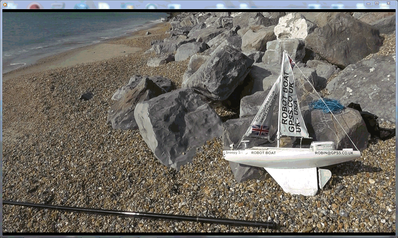
Imagine Robin's delight when he received a 'phone call at 8am from heroic friend Dick (see March launch attempts below), to say he had reached the boat, where it had beached on a remote stretch of "tricky" coast, east of Yarmouth, Isle of Wight.
Dick had remained on the coast all night, watching the SPOT map updates, and looking through a telescope at Snoopy's navigation light. He saw it beach, in the early hours, and took the car ferry to Yarmouth. He then had an "interesting" walk along the coast, past mud slides and tangled undergrowth.
Snoopy returned home, and has been undergoing tests on Bray Lake. These show we need to fix a "Zig-Zag" sailing problem. We learnt a lot more from this attempt, and Snoopy will make another Atlantic attempt soon ! :-)
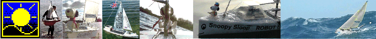
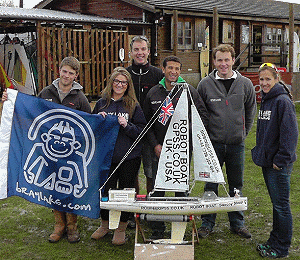
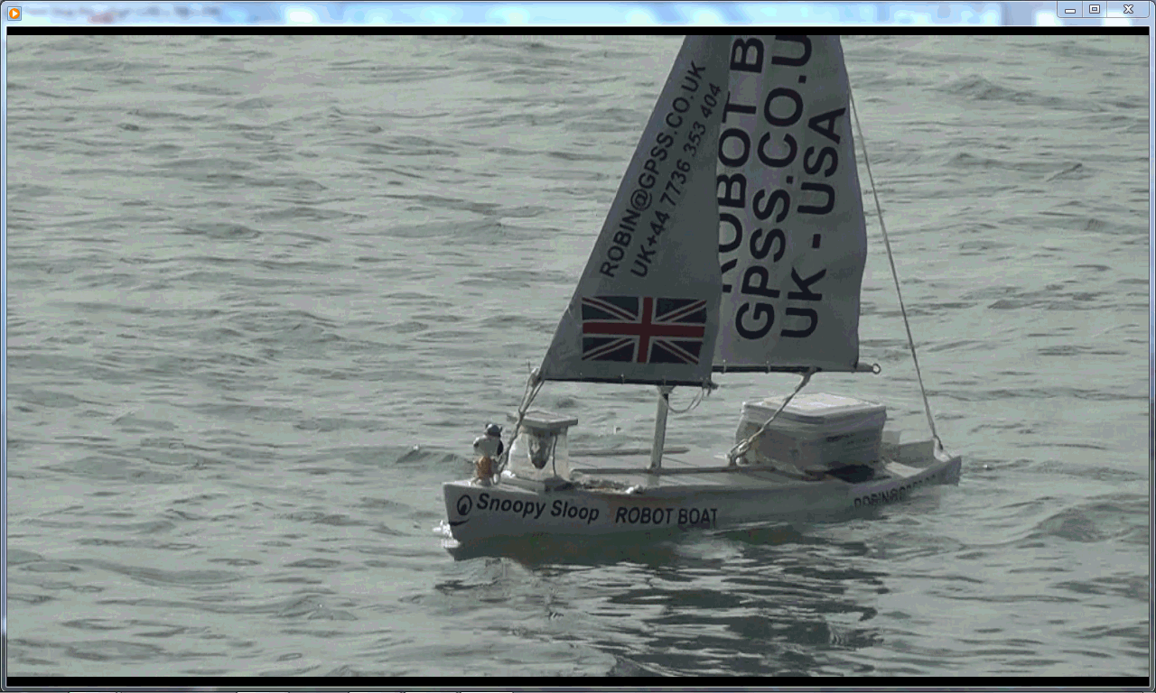
Snoopy is behind you, Peter and Dick ! :-) There were five of us at the launch: Robin and June, who brought Snoopy on his latest boat, Snoopy Sloop 9, referred to below simply as "boat9"; Peter, our photographer friend, who did sterling work in last year's search for Snoopy; Dick, who you may know from our exploits in March, nearly being swept away by the waves; and Roz, from the BBC: we had not told them, but they had been monitoring this web site, and could see the date and hour approaching.

Robin walks a few paces each way, to reset the rudder trim logic... launches at 1215... these frames are from the first minute ...

 The launch could not have been easier: no need for a rope around Robin's waist: just wading in and carefully letting Snoopy go ...
No need for the telescopic pole, in case the surf threatened to wash Snoopy up, as twice last March. Thankyou MagicSeaweed ! :-)
However, even within the first minute, we could see that Snoopy was not steering as straight a line south as he had last year. For maybe one or two hundred yards, before he left the shelter of the cliffs, the wind was light and variable.
At one point, Snoopy even headed towards us, and someone said "he's coming back to wave a final goodbye" ! He then turned and continued his zig-zag course, away from the shore.
Later, as he got further away, the wind began to strengthen on his sails, but he still failed to sail a straight line.
Not long after launch, we had moved back to the car park, on the cliffs, to watch with binoculars and Dick's telescope. Occasionally Robin would snatch some video, through the telepho lens, to include passing boats. When the rain arrived, we enjoyed some warmth and refreshments in The Beachcomber Cafe. The rain did not last long, and we followed Snoopy up the coast, to a car park at Milford on Sea.
 It was clear the boat was being carried by the tide, and acting completely differently to boat8 last year.
Robin and June left, to go home, but at 3pm received a 'phone call from guys doing survey work, that we'd seen and filmed in the area. They had not touched the boat, but had seen the 'phone number on the sails, and asked if he needed a rescue. Robin thanked them, and said we would learn more if they let him continue.
Robin and June returned to join Dick again, and shot some more video. On the left you may just be able to make out Snoopy, in the low-centre, sailing to our left (east), and the survey boats. Robin has spoken to Colin more recently, and hopes to put up more information from them soon. You should also be able to see what is probably the survey vessel, and two RIBs (Rigid Inflatable Boats), one of which held the guy who 'phoned Robin.
This picture shows again Snoopy's tendency to sail towards the east, as if "weather helm" from a strong North-East wind was having it's undesired effect, due perhaps to this later boat not being as well balanced as the earlier one. Sometimes, looking through the telescope, sat on it's tripod, we could see that the boat might appear to be sailing strongly one way, but in fact moving in the opposite (backwards) direction. No surprise there, particularly when the tide is flowing closer to 2 knots/mph, faster than Snoopy is likely to be sailing !
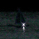
Dick continued to watch Snoopy, after we finally left, to return home. He remained in contact with Robin, and used the tracker to know where to look with his telescope. He continued to watch after it became dark, and Snoopy's navigation light came on. At one point, Dick travelled to observe much further west, south of Christchurch. This was when Snoopy had travelled much further west, carried by the tide.
 That night, Robin was able to relax at home, and take the occasional look at his laptop screen, showing the updated SPOT positions,
coming in every hour. He would get the occasional text or 'phone call from Dick, who was working in more "Spartan" conditions,
from his car.
That night, Robin was able to relax at home, and take the occasional look at his laptop screen, showing the updated SPOT positions,
coming in every hour. He would get the occasional text or 'phone call from Dick, who was working in more "Spartan" conditions,
from his car.
Below, you will see the map that many others were also watching, in the UK and far away. Here we have added some more information, including that worrying period when we thought Snoopy's SPOT tracker had stopped working. As we hoped, the lost position reports were probably simply due to loading on the SPOT system, at the weekend, when many users decide to "go walk about".
Robin did wake up, in the middle of the night, looked at the laptop screen beside the bed, and saw Snoopy had landed. Early next morning he was pleased to see that reports were still coming in from the tracker, so it looked as if Snoopy had not hit rocks, as he had a year earlier.
Luckily for Robin, his next 'phone call was from Dick at 8am, saying that he was standing beside Snoopy. If Dick had told Robin his plans, to jump on a ferry, Robin would not have got any sleep at all through worry. Why ? Take a look near the bottom of this page, and what it says about this same stretch of the Isle-of-Wight coast ! :-)

Dick stayed down at the coast, that Friday Night. He had his telescope and a smartphone to track Snoopy. The following are edited extracts from Dick's account, emailed to Robin ...
"After Robin and June left me at Milford on Sea the drizzle got a bit worse so I retreated into the car and tried watching snoopy from there. However this turned out to be a mistake because by the time I'd repositioned the car for the best view I was struggling with condensation on telescope lenses and the inside of the windscreen and drizzle on the outside. I sort of overcame these problems but found the visual clarity through the windscreen was not good and I failed to locate Snoopy again.
 I can't remember the times exactly (I'll keep a log next time) but I think I waited for the next Spot report which confirmed he was going West so I moved back to Barton on Sea and set up the telescope in the 'shelter' on the grass between the car park and the caf�. It was from there that I spotted his light and was able to track him for a while. The light was occasionally clear through the telescope but would often fade or disappear as he bobbed around in the waves and at times I guess the light was masked, or half masked, by the sail. He moved from south-south-west of me, westward, until he was to my south-west. To the west-south-west and west were a number of markers and buoys with lights associated with Christchurch Harbour entrance but they were either coloured or blinking in a regular pattern. Occasionally lights, further west at Bournemouth, were also reflected off the waves in little flashes but through the telescope Snoopy's irregular white light kept making it's slow steady progress across the telescopes field of vision. With the naked eye it I could not see him at all, but through the telescope it was a bit like watching the progress of a planet across the night sky.
As he was still going West, I moved to the car park we had all visited previously at Highcliffe, collecting Burger with Pineapple and Chips on the way (not the best I've had but ...), and again set up in the shelter overlooking the cliff. This time try as I might I couldn't find his light for certain. The drizzle had stopped and the air had cleared and it's surprising how many different lights from buoys etc. there were. Also I was uncertain exactly where to look as there were no position reports coming in. Finally the 22:18 one arrived giving the impression he was now sailing towards the South-West.
 So I quickly moved to Southbourne, East of Christchurch Harbour, where I walked the length of the beach on the south side of Hengistbury Head, and out to the end of the breakwater, on the point in the hope of spotting his light. I mistakenly referred to this spot as Hurst Castle in earlier accounts because that's how Google maps titled it, but I now realise that's wrong. In fact Google marks two spots as Hurst Castle, the other being the correct one on the north side of the Solent West entrance.
Just as I arrived at the very end of the breakwater, the 23:23 SPOT report arrived, showing he was heading back East. So I walked back to the car (that walk there and back was lovely as described earlier), found an all night Sainsbury garage, filled up, and treated myself to a coffee and Mars bar.
I parked in a layby as the midnight SPOT report was about due.
When it came, he was still going East, so I looked for the nearest location to Hurst Castle (the real one not the Google false one), to see if there was a view point I could use.
 I ended up parked in SaltGrass Lane, a little south and midway between Milford on Sea and Keyhaven. I couldn't find a suitable viewing spot in the dark, so waited for the 01:15 report which showed he'd been unable to obey Robin's autopilot software, to turn West on crossing Robin's 'Head West Line', and was clearly being swept in by the tidal current. Was he sailing in reverse, trying to obey Robin's code? Would he be swept into the Solent regardless? Would the tide turn and spit him out again?
Would the North wind dominate and push him South towards the IOW shore ?
I could only wait and see what the next report showed.
I ended up parked in SaltGrass Lane, a little south and midway between Milford on Sea and Keyhaven. I couldn't find a suitable viewing spot in the dark, so waited for the 01:15 report which showed he'd been unable to obey Robin's autopilot software, to turn West on crossing Robin's 'Head West Line', and was clearly being swept in by the tidal current. Was he sailing in reverse, trying to obey Robin's code? Would he be swept into the Solent regardless? Would the tide turn and spit him out again?
Would the North wind dominate and push him South towards the IOW shore ?
I could only wait and see what the next report showed.
I turned some music on, and waited. When the 02:17 report came, it was clear he'd been carried into the Solent. Nothing to do but see if the next report showed him escaping to the West. One thing I was clear about, was that if he came ashore, the quicker he was located and rescued the better, before batteries died or waves damaged him breaching his 'water tight' containers or, heaven forbid, some malevolent characters kidnapped him. I needed the 3 o'clock report to determine what to do next, but in the meantime I decided to turn all lights off and get an hours sleep while I waited.
 I was woken by a giant dog, an Irish Wolf Hound I think, thumping on the bonnet with his forelegs, curious about anything inside the car. There was someone with a very strong torch walking along the top of the five foot bank beside the lane (which is underwater at spring tides according to the notices). I was expecting to be ticked off for parking there but I was just ignored. Anyway that was fortunate as I'd overslept and it was about 03:45.
I eagerly checked the 03:14 position report and found Snoopy was against the shore. So decided I had to check options to cross to the IOW if the next report showed him still there. I did a bit more Googling to locate the nearest ferry and check it's timetable. It was Lymington only a short drive away but the first ferry of the day didn't leave till 05:35. I drove straight there to be first in the queue and awaited the 4 o'clock report. When I received the 04:15 report he was at the same spot so I knew that I should get there soon and that it was quite likely he'd still be there. I was able to zoom in to satellite view and see that it should be an accessible shore and also where the nearest access point was. Not long to wait then .... "


 That certainly was a "tricky" path that Dick trod, along 0.7 miles of muddy beach to Snoopy.
This section is still being worked upon, but for now, here below is some of Dick's email to Peter and I. We now know how far it was along that beach, between Dick's car and Snoopy, and how far from where one of the GPS bottles landed a couple of years ago. See near the bottom of this page for that, but here are Dick's recent words:
"Recovering Snoopy I walked 1,237 yds. along Bouldnor shore - can't bring myself to call it a beach :-) I reckon Harry Hampshire was just 1100 ft. further on, how spooky was that!!"
Here is Dick's earlier account of the rescue ...
" It was rather a saga and a bit of a challenge, just what I like, a mini adventure. Firstly because the road I pick to reach the shore was based on my car satnav, my iPhone maps, OS maps on the iPhone and Google earth satellite view. The first ferry, 05:35pm, got me on the IOW in the dark, but the route to chosen road was closed due to a nasty RTA ... "
"... it was an unadopted, unmetalled, narrow track between trees and hedges, (called The Avenue!), which further along became a narrow bridal way through dense woodland and the an wide footpath thick shrubs and more dense woodland, wing mirrors in the bushes either side but I just kept driving between them following the footpath, it takes a lot to put me off. However finally I could no longer do that as I meet a bush right in front of me and the track ended. It was still dark though the occasional light drizzle had abated.
 "
I had a look around with a torch and found that the path I'd been following had arrived at a 'T' junction with the coastal path,
as indicated by a sign post in the undergrowth. So the maps had helped. The 'T' junction just about allowed a for a ten point turn,
burying the front and back of the car in the bushes with each two foot move, (thank goodness for power steering).
Now with the car facing the right way to get out when I was ready, I made a good decision to put my wellies on and I also took a tow rope,
just in case of ... well something, (actually I never needed it and it was more to carry). I set off down the costal path in
the direction of shore and soon understood why it was regarded as 'a bit dodgy'.
"
I had a look around with a torch and found that the path I'd been following had arrived at a 'T' junction with the coastal path,
as indicated by a sign post in the undergrowth. So the maps had helped. The 'T' junction just about allowed a for a ten point turn,
burying the front and back of the car in the bushes with each two foot move, (thank goodness for power steering).
Now with the car facing the right way to get out when I was ready, I made a good decision to put my wellies on and I also took a tow rope,
just in case of ... well something, (actually I never needed it and it was more to carry). I set off down the costal path in
the direction of shore and soon understood why it was regarded as 'a bit dodgy'.
" It was just day break by then ... The muddy land slides had also brought down many of the trees seen in your photo and the tide was right up so the shore was littered with trunks and branches. Walking out round them would mean water going over the top of my wellies and also stepping in soft mud risking them being stuck. So I instead clamber over most of them. The shore clearly is still at risk of sliding down during heavy persistent rain but I judged slop to be stable at the time.
" It was think a ploughed field of heavy clay soil, clingy. Between the branches at the high tide line the soft stuff had been washed away leaving a harder though, sticky and slippier surface, a bit like clay that potters use. Where more clay had been washed away the stones in it had been left like large grade 'sharp' gravel, not the smooth rounded stuff usually found on beaches.
Eventually I was excited to make out Snoopy lying high and dry, I'd feared he'd be lodged amongst some branches and become free and after all my effort I suddenly catch sight of him drifting past and away. (I used the maximum 'pseudo' zoom on an app I have for the iPhone to get this, even more camera shake)
I'd found him now all that was left was to reach him across the mud, which was everywhere. Finally no more obstacles I'd reached him. That's well washed hard clay not rock behind him, I guess it will become rock in a few million years time though! You can even see some of the trees on the shore in Google maps satellite view.
May be I should have waited for the tide to go out more then I could have walked around the trees. I found this photo on Google Maps . I would have missed my cheap economy ferry return fare, as it was I only made the 'check in' by ten minutes."
from Robin again: We may be adding some more pictures and information here soon. Sorry for any typos, etc. Well Done Dick ! :-)
Quite a few tasks can be done in parallel, particularly where there may be others helping. e.g. grabbing an hour or two over at Bray Lake when the weather is right, such as a strong wind, to try "The Bray Lake Test".
This page saves time in discussion with those in direct contact. Here are the tasks that immediately come to mind ...
Snoopy's Bray Lake Test ... sail 530 metres automatically, through 5 waypoints ...
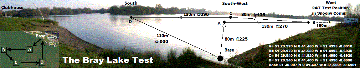
Comparison between last year's attempt and this, may help us discover more quickly what to change, so Snoopy may have a better chance in his next attempt, expected before Christmas. e.g. the length of keel differs between boat8 and boat9, so perhaps the same autopilot software coped less well, steering to a distant waypoint in strong winds ? We might be able to recreate this on Bray Lake, on a suitably windy day, adjust the steering, and test again.
Here is a list of topics for comparison:
Last year we expected something similar to happen as this year - with the simple "GPS-Only" autopilot being "confused by the tide", resulting in useless steering, and Snoopy simply being swept with the tide. But this is not what happened. The good first two hours, within 3 degrees of his distant "channel" waypoint direction, made us realise that the design WAS capable of coping with a moderate tidal current, maybe as fast as 2 knots.
But maybe our latest boat needs "adjustment", such as the gearing of the rudder, and/or time it is held over. If the problem was related to the balance of the boat and "weather helm" (wind on mainsail causing boat to turn towards wind), then this might be reduced by adjustment of mast position and/or sails. Last year's boat8 can be seen in the "Robin thanks his friends ..." section below. The "nitty-gritty" of design and construction of both boats is on the Design and Blog pages. Our recent thoughts were that the problem this year may have been due to Snoopy trying to sail more directly downwind to his first "Channel" waypoint. We've updated the bottom of the search page with more complete data. It seems Snoopy was trying to sail almost directly downwind, in both attempts.
Note added in June 2014. The rest of this page was written last year, before we had found the causes of Snoopy Sloop 9 sailing so erratically compared with the boat used in the previous year's attempt. The conclusion in June 2014, after weeks and months of tests and changes to the rescued boat 9 (which becomes boat 10 for 2014) is that the problem was some unknown combination of: the rudder having slipped from it's correct, central position, and balance of the boat, including things like mast position, position of the rudder, and degree of rudder "gearing". It could have been a combination of these, or just one thing. e.g. the grub screw coming loose that holds the servo linkage arm to the rudder post ! One thing is for sure: in early 2013, we should have done more thorough functional tests, using the "Bray Lake Test", including sailing in all directions relative to a strong wind - before we rushed into the required 24/7 reliability tests !
 This section will receive updates in the coming days, as we reach firmer conclusions about
why Snoopy acted so differently in this October 2013 attempt, compared with last year's
November 2012 attempt. These words should be regarded as "speculation", until we have
done more analysis - but most important of all - more sailing tests on Bray Lake.
This section will receive updates in the coming days, as we reach firmer conclusions about
why Snoopy acted so differently in this October 2013 attempt, compared with last year's
November 2012 attempt. These words should be regarded as "speculation", until we have
done more analysis - but most important of all - more sailing tests on Bray Lake.
We can summarise our initial "conclusions" as:
Numerous things are being done, day by day, including investigating things like recent SPOT transmissions stopping, finding the problem, and fixing it. The nitty-gritty of engineering repairs and testing on Bray Lake, are reported near the end of the Blog page. That is not a page for the faint-hearted :-)
The blog mentions a "Bray Lake Test" : "Friday 14th June: Snoopy was pining for Bray Lake, so he was given a test sail, around the usual "Bray Lake Test" waypoints, in a southerly wind of about 15 to 20mph. As expected, he took ages (45 mins?) to reach the first waypoint, almost directly upwind, but then returned much faster, within maybe 15 minutes, and within a metre of his base." The picture on the right was taken during this test, and a video was put up then. You can play the 2 minute Video of June 2013.
If you watch the end of the video above, when Snoopy does his "impressive" accurate return to base, you will clearly see he is taking a very zig-zag course. We have been looking at this over the past year, thinking that - if we can solve the problem - it will greatly increase his downwind speed. This may account for this year's failure to sail a straight line. It could be differences in ability of last year's and this year's boat, to sail without zig-zag directly downwind.
Recently we thought: "What if Snoopy was trying to sail far closer to an exact downwind path, to that first "Channel" waypoint, this year, compared with last year ?" We were missing the wind direction data from last year, for the period from launch at 1130 to 1530, which includes when he sailed a perfectly straight line, within just a few degrees of the destination direction, of 187 degrees. However, we now have this data, at the bottom of the old search page. It shows that, in both year's events, Snoopy was trying to sail directly downwind to the destination waypoint - so this is probably not the explanation.
We need to continue looking for differences between the two boat systems, including old 2012 videos of the old boat doing "The Bray Lake Test", and sailing directly downwind.
The solution for us would then be easy, if sailing directly downwind is the problem: choose a slightly different "weather window", with wind NOT directly from the North. We know a boat can happily sail out and back, in such a wind, from our first sea test of boat 6, in 2012, for which there has been is a video, and this picture of it, on our front page since last year.
 Theory: This year's problem due to this year's boat "under-steering" ? The above is still true, but maybe
the problem this year was simply due to the difference in steering sensitivity between this year, and last year's, boats ?
If you look at the June 2013 video above, you will see that the "zig-zag time" was much slower than the autopilot 7 second cycle.
This would be no surprise: that longer keel this year, and rudder further back last year. The rudder could be given more
movement, by simply putting the servo-rudder linkage into a different lever hole. Tests on Bray Lake should enable us
to repeat the problem, then see if we can reduce the zig-zag when sailing downwind, by a simple rudder modification or adjustment.
Theory: This year's problem due to this year's boat "under-steering" ? The above is still true, but maybe
the problem this year was simply due to the difference in steering sensitivity between this year, and last year's, boats ?
If you look at the June 2013 video above, you will see that the "zig-zag time" was much slower than the autopilot 7 second cycle.
This would be no surprise: that longer keel this year, and rudder further back last year. The rudder could be given more
movement, by simply putting the servo-rudder linkage into a different lever hole. Tests on Bray Lake should enable us
to repeat the problem, then see if we can reduce the zig-zag when sailing downwind, by a simple rudder modification or adjustment.
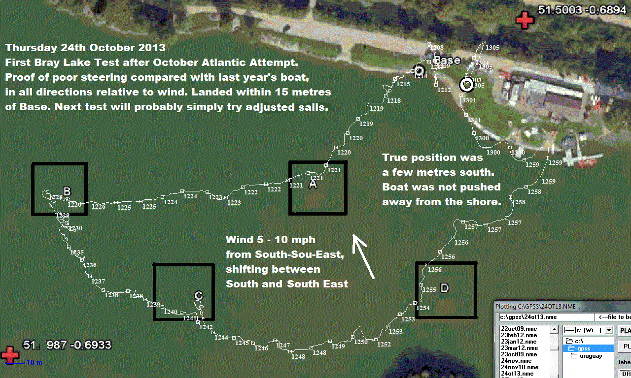
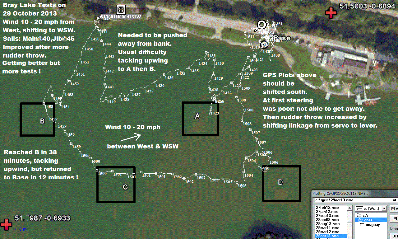 <- GOOD NEWS ! Click on the picture on left, to see this GPS plot from Snoopy's first test,
after his October Atlantic Attempt. This confirmed the steering was terrible compared with last year's boat.
Even BETTER NEWS: Click on the picture on the right, to see the result of simply clipping the servo linkage
into a different hole, to increase the rudder movement - back to what it was ?
<- GOOD NEWS ! Click on the picture on left, to see this GPS plot from Snoopy's first test,
after his October Atlantic Attempt. This confirmed the steering was terrible compared with last year's boat.
Even BETTER NEWS: Click on the picture on the right, to see the result of simply clipping the servo linkage
into a different hole, to increase the rudder movement - back to what it was ?
We hope to do better than just change the weather window. We want this boat to perform as well as earlier boats, in all directions relative to the wind. This means we will soon be testing more adjustments to rudder and sail-settings on Bray Lake, in different wind conditions.
We may still decide to choose a launch day with something other than a North Wind ! :-)
Boat 6 managed to sail away, then back, a short distance, in a wind that was not off-shore, in the summer of 2012.
Perhaps we could relax our launch "Weather Window" a little ? :-)
 Below is the "Robin thanks his friends" on the front page last year. This shows the 2013 boat #8,
and you will see it has a smaller keel ! These people have all contributed to the work and preperation for this 2013 October attempt.
However, it is clear from the words and pictures above that a very special thankyou must be given to Peter and Dick.
Below is the "Robin thanks his friends" on the front page last year. This shows the 2013 boat #8,
and you will see it has a smaller keel ! These people have all contributed to the work and preperation for this 2013 October attempt.
However, it is clear from the words and pictures above that a very special thankyou must be given to Peter and Dick.
Peter made contact with Robin last year, and did the amazing "photo recce" which helped us piece together what happened to Snoopy in November 2012. Peter came this time to the launch, and has some excellent quality photos. Peter may be contacted via Robin, or Peter's site which is now linked from his name below.
Dick made contact with Robin in 2013, during the testing of Snoopy on Bray Lake. You will see Dick in the pictures and video from our March 2013 attempts - including taking a bath with Robin in the sea ! :-) Peter may also be contacted via Robin. Dick stayed on, after Robin, June and Peter returned home on Friday evening, and continue to monitor Snoopy from the mainland. He saw where Snoopy had landed, on the Isle of Wight, and made that epic trek by ferry, car, and on foot, to find and then safely return Snoopy home. While doing this, he also recorded it all with photos and video, and some of this appears above, and is included in our video on this chapter in the Snoopy Trans-Atlantic Saga :-)
from Robin : I'm glad I did not know about this before Dick 'phoned me, standing near Snoopy on that "tricky" beach !
Here is a recent quote from Dick: "
Recovering Snoopy I walked 1,237 yds. along Bouldnor shore - can't bring myself to call it a beach :-)
I reckon Harry Hampshire was just 1100 ft. further on, how spooky was that!!"
This is under "latest news - updated Friday 5th August 2011 ..." on
BBC Bottles page ...

DO NOT TAKE RISKS TRYING TO FIND HARRY OR DOLLY !
Robin spoke to Matt at the IoW Council's Parks & Countryside department who said
this is NOT a stretch of beach to be tackled by people unless they "know what they are doing".
Furthermore, it is thought that this beach is privately owned, despite what looks
like a public footpath on the Ordnance Survey map. Access may be best by boat - and that only by people
who know what they are doing. You have been warned !
See "searches" below.
Harry Hampshire has still not been found !
Harry sailed past Cowes on Tuesday night, then beached 2 miles east of Yarmouth, IoW.
searches: Roger searched 1.75 miles of beach at low tide on afternoon of 26th July, between
Bouldnor and Hamstead; found nothing; very little weed for a broken Harry to hide in. Maybe Harry
moved eastward, freed by strong wind and waves to east, on 15th and 16th.
On Thursday 28th Roger searched over two miles of beach from Hamstead to the mouth of the Newtown Estuary: no find.
Roger is 80% certain he would have seen Harry, if he were on the beach.
Thanks for the searching and photos Roger. Maybe Harry is even further east, such as the east
of Newtown Bay, or even as far as Thorness Bay - where Flashing Fred turned up ???
See the
Ordnance Survey map
for these places in detail.
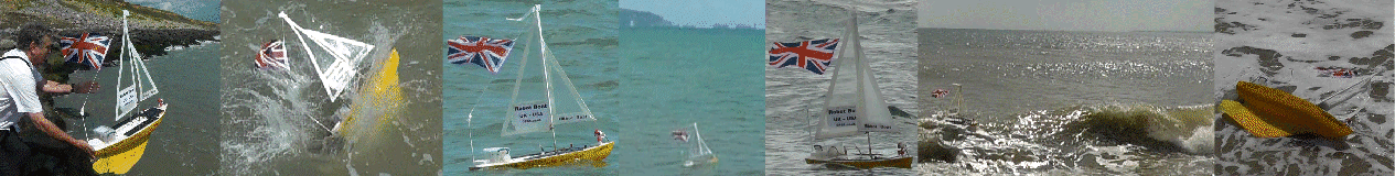
Here are some frame grabs from Robins video ...
waiting ,
walking ,
launching ,
waving :-)
Peter can be contacted, via Robin, and can supply far better quality photos than you see here.
© 1991-2013 Robin Lovelock. Please credit www.gpss.co.uk if you use material from any of these pages. Thankyou.

the search for Harry on the Isle of Wight
 The winds continued to blow inshore, days after he landed on Wednesday 13th July, and his GPS tracker continued
to work for a few days, reporting the same position. He may have moved since then.
We thought he might still be there, near Bouldnor-Cranmore-Hamstead.
See the detailed
Ordnance Survey map
of where Harry landed:
on google maps, it is
here.
The winds continued to blow inshore, days after he landed on Wednesday 13th July, and his GPS tracker continued
to work for a few days, reporting the same position. He may have moved since then.
We thought he might still be there, near Bouldnor-Cranmore-Hamstead.
See the detailed
Ordnance Survey map
of where Harry landed:
on google maps, it is
here.
 That last reported position seems to be near rocks,
at the western edge of the beach. Robin's first guess was that Harry may have nestled up against the disused pier.
This spot might be reached from the east: a footpath down from Hamstead,
a walk of about 1000 yards along the beach. Alternatively, maybe a mile walk from the west, from Bouldnor, near Yarmouth.
Low tide may be the best time to look for Harry: times are
here.
If he broke his nose on rocks and sank, he might then be seen. Beach access might also be easier at low tide.
For those with a GPS, the last reported position was lat/lon 50.71684 -1.45513 - in decimal degrees,
or - if your prefer - N 50 43.01 W 1 27.3078 in degrees and minutes.
That last reported position seems to be near rocks,
at the western edge of the beach. Robin's first guess was that Harry may have nestled up against the disused pier.
This spot might be reached from the east: a footpath down from Hamstead,
a walk of about 1000 yards along the beach. Alternatively, maybe a mile walk from the west, from Bouldnor, near Yarmouth.
Low tide may be the best time to look for Harry: times are
here.
If he broke his nose on rocks and sank, he might then be seen. Beach access might also be easier at low tide.
For those with a GPS, the last reported position was lat/lon 50.71684 -1.45513 - in decimal degrees,
or - if your prefer - N 50 43.01 W 1 27.3078 in degrees and minutes.
Back to October 2013 and Pictures for the Press ...