
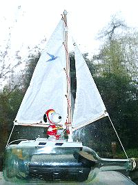
 Click on
GPS Guided Trans-Atlantic Robot Boat,
or the animated picture above,
to know more about Snoopy the Viking's attempts to sail
from UK to USA in his little robot boat.
Click on
GPS Guided Trans-Atlantic Robot Boat,
or the animated picture above,
to know more about Snoopy the Viking's attempts to sail
from UK to USA in his little robot boat.
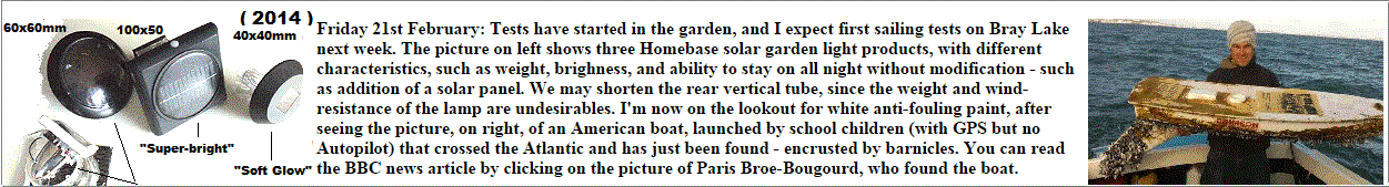
 This page is about another little boat that DID make it across the Atlantic,
from USA to UK, and without the help of an autopilot.
School kids in the USA built the boat, and watched it
being carried by wind and tide, until it eventual reached the shore.
They could then watch it being carried to a house for safe keeping.
This page is about another little boat that DID make it across the Atlantic,
from USA to UK, and without the help of an autopilot.
School kids in the USA built the boat, and watched it
being carried by wind and tide, until it eventual reached the shore.
They could then watch it being carried to a house for safe keeping.
I thought those guys in the USA deserved their own page: Well Done Kids ! :-)
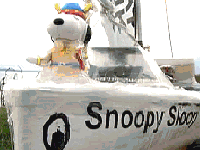
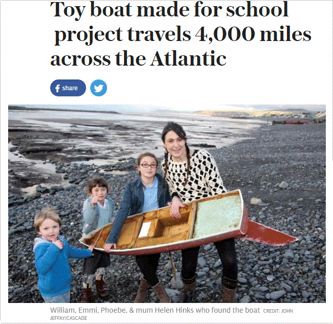
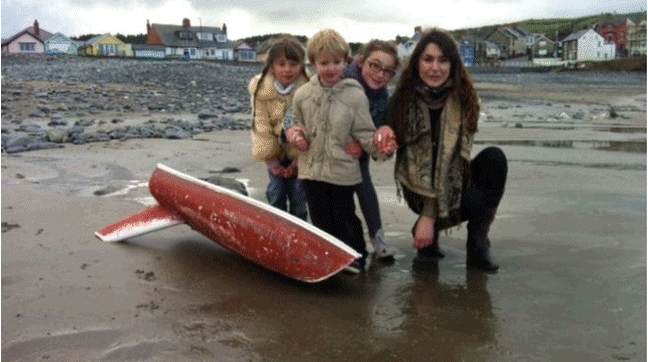
Not just the school kids in the USA who built and tracked the boat across the Atlantic, but Helen Hinks and her children too, who saw the boat sail in, and then collected it ! :-)
If anyone has information, I'm Robin Lovelock on robin@gpss.co.uk and 01344 620775 - as on our Contact page. Helen told me that the boat landed at about 1520 GMT on Tuesday 2nd February. i.e. much earlier than the 10th March in the Telegraph.
Click on the picture to the right for the
Telegraph article emailed me by Ian Pestell,
received at 2222 GMT on 22/02/2016 - not easy to forget !
The Telegraph article said:
QUOTE:
The boat was found on Borth beach, around eight miles from Aberystwyth, by local woman Helen Hinks on February 10th.
( 2nd February )
"We were looking across the waves when it literally sailed right to us," she told the BBC."It was magical."
UNQUOTE.
Did the journalists wanted to make it more recent news ? :-)
 You can go direct to the
BBC Article here
, or click on the picture on the left.
It confirms that the date Helen and her boys saw it land was
about a week before the media interest.
QUOTE:
Ms Hinks said she did not realise the significance of the boat until seeing media reports a week later.
"When we contacted the school they were really excited. My children's school is hoping to relaunch it back to America," she said.
UNQUOTE.
Dick Baldwin, the boat designer, was chatting to me about putting an autopilot option
into his boats two years ago, and Carolina Dreamer has re-kindled our interest again.
If there is any way I can help, I will, but don't under-estimate
the difficulty of making the modified boat capable of surviving more than a few days.
The good news is, that if the tracker keeps going, you can probably go and collect it,
after it washes up on the UK mainland. Maybe they should keep Carolina Dreamer on display somewhere,
and take one of Snoopy's old boats from my garden :-)
You can go direct to the
BBC Article here
, or click on the picture on the left.
It confirms that the date Helen and her boys saw it land was
about a week before the media interest.
QUOTE:
Ms Hinks said she did not realise the significance of the boat until seeing media reports a week later.
"When we contacted the school they were really excited. My children's school is hoping to relaunch it back to America," she said.
UNQUOTE.
Dick Baldwin, the boat designer, was chatting to me about putting an autopilot option
into his boats two years ago, and Carolina Dreamer has re-kindled our interest again.
If there is any way I can help, I will, but don't under-estimate
the difficulty of making the modified boat capable of surviving more than a few days.
The good news is, that if the tracker keeps going, you can probably go and collect it,
after it washes up on the UK mainland. Maybe they should keep Carolina Dreamer on display somewhere,
and take one of Snoopy's old boats from my garden :-)
 I've been adding more information to this page,
after digging out old emails dating back to 2014,
when I first spoke to Dick Baldwin.
The most important information has come in more recently,
such as GPS data from Dick, speaking direct with Helen, and receiving wind data.
i.e. the direction and speed of the wind, which determines the direction
these boats, without an autopilot, move.
I've been adding more information to this page,
after digging out old emails dating back to 2014,
when I first spoke to Dick Baldwin.
The most important information has come in more recently,
such as GPS data from Dick, speaking direct with Helen, and receiving wind data.
i.e. the direction and speed of the wind, which determines the direction
these boats, without an autopilot, move.
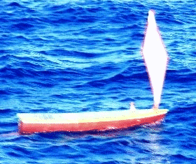
It seems that Hurican Imogen did not come through until a week later, around the 8th of February. We now need to check that Carolina Dreamer only travelled downwind when she went through St Georges Channel, through to arriving at Borth. This, combined with the low speed, will confirm the boat was not given a "helping hand".
The same analysis of boat's GPS track vs wind direction, may show where Carolina Dreamer lost her sail: the boat would have gone much slower. Here are questions Dick Baldwin may answer: does that lovely labelled deck come off easily ? Does it float ? Is it probable it came off at the same time as the mast and sail ? If so, we might then guess where it might come ashore. It would be nice to put it back on the hull :-)
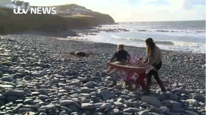
I see that, back in February 2014, after that barnicled boat piece below, I found the web site educationalpassages.com. On that I found the same boat: Carolina Dreamer. Follow this link to more detailed news, including from Dick Baldwin, BBC, and ITV News pages. Check out the lovely ITV News Video link, or click on the picture above to play it.
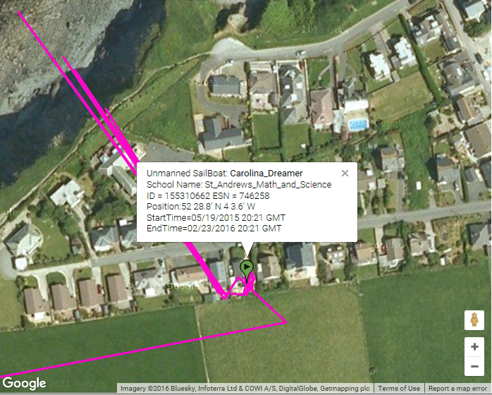
In May 2015, there was another flurry of emails with Dick Baldwin, who gave me this link to their 2015 Tracking Page. It includes the track of Carolina Dreamer.
Click on the map below to go to their tracking page, where you can zoom in to more detail - including the house that the boat was taken to.
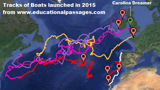 The track shows that, like all the other boats, Carolina Dreamer probably did
not have an autopilot. Dick confirmed this.
It did not ! :-)
The track shows that, like all the other boats, Carolina Dreamer probably did
not have an autopilot. Dick confirmed this.
It did not ! :-)

What an amazing coincidence that it landed so close to Aberystwyth, the "hub" of Microtransat :-)
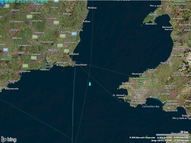
Click on the map on the right, to enlarge it, and show the last few days of Carolina Dreamer's voyage.
The same map appears further down this page, where we look more closely
at how fast the boat travelled, to confirm this matches the effect of wind and tide.
That would show if and when it "got a helping hand", as Snoopy did in 2015.
Speed of the boat, measured by looking how far it travelled each day,
might also show when it lost it's deck and sail - perhaps after a collision
in a busy shipping lane.
![]()
The text beside the picture below is from
Snoopy's Blog2 from February 2014.
It was this picture that made me decide to put anti-fouling paint on Snoopy's hulls !
Click on the picture for the BBC Article.
If you browse the "Educational Passages" pages, you will find that this barnacled boat
was "Crimson Tide", launched on 1st December 2012, but not found until over 14 months later.
Looking at all the other boats, after they crossed the Atlantic, they seemed free of barnacles.
Maybe we don't need anti-fouling paint after all ?
Maybe that boat below had spent many months near the shore ?
How many barnacles swim around on the surface, hoping to attach themselves
to passing boats ? I think I found the
GPS data for Crimson Tide.
It was not difficult to scroll through the data, to see when the boat got to near where it was found: ~ Lat 49.43,Lon -2.6.
But had difficulty making sense of the date. Maybe one of you will do better, working out how long it was there ?
I reckon it could have spent many weeks on the shore: plenty of time for barnacles to climb aboard :-)
![]()
 I see that the GPS sat/com tracker is still reporting the position of Carolina Dreamer, from the house
the boat is being kept. It's not too difficult to pick out the house on Google Streetview either.
I see that the GPS sat/com tracker is still reporting the position of Carolina Dreamer, from the house
the boat is being kept. It's not too difficult to pick out the house on Google Streetview either.
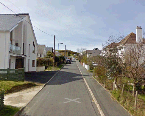 If Helen and her family, or others, are a bit nervous about seeing their house on the right,
I've added these words here. I can obviously change this page easily if asked.
One cannot be too careful what is put on the Net, but very few people visit this page.
Those that do will probably be seen visiting on the World map below.
Click on it to see more detail, including the exact time of their visit,
and roughly where they are. You should see yoursef !
If Helen and her family, or others, are a bit nervous about seeing their house on the right,
I've added these words here. I can obviously change this page easily if asked.
One cannot be too careful what is put on the Net, but very few people visit this page.
Those that do will probably be seen visiting on the World map below.
Click on it to see more detail, including the exact time of their visit,
and roughly where they are. You should see yoursef !
At first I thought those movements from the house to the beach were the trips with the boat for journalists: the links above show several "photo shoots". However, it seems far more likely that this is the normal "GPS scatter" seen when the GPS is under a roof without access to open sky. It will be interesting to see if the boat continues to report position, and where it goes next :-)
![]()
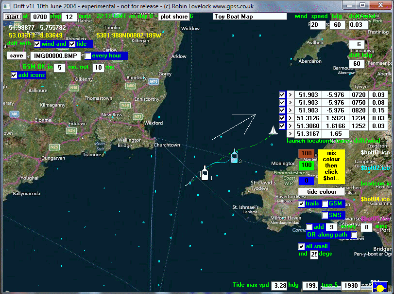
The tracking seems to give a position twice a day, at about 8:20am and 8:20pm.
In "navigation speak" that's 0820 and 2020 GMT.
If the boat is not following a perfectly straight line, we can see each of these positions. So, south of Ireland, we can see how far the boat travelled in 24 hours.
 We don't need to worry about the effect of the tide - unlike with Snoopy's adventures !
The tide will have completed a full cycle in 24 hours, and the effect of it will have
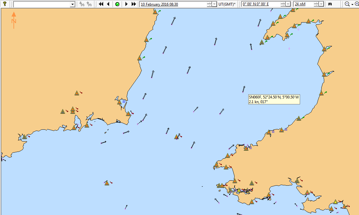
cancelled out. For those interested, enlarge the tidal current map on the left by
clicking on it. As it happens, at 0830 the tidal current was at it's maximum speed,
of 2.7 knots ( roughly 3 mph or less than 5 kmph ). Don't forget that half the time
it is flowing one way, and the other half it's in the other direction - cancelling out.
We don't need to worry about the effect of the tide - unlike with Snoopy's adventures !
The tide will have completed a full cycle in 24 hours, and the effect of it will have
cancelled out. For those interested, enlarge the tidal current map on the left by
clicking on it. As it happens, at 0830 the tidal current was at it's maximum speed,
of 2.7 knots ( roughly 3 mph or less than 5 kmph ). Don't forget that half the time
it is flowing one way, and the other half it's in the other direction - cancelling out.
So the main factor moving the boat is the wind - or someone in a full sized boat giving it a "helping hand". The key question is when was it at those positions either side of St George's Channel ? If that is 12 hours, that looks too fast for that little boat to sail. Of course, the straight line may hide one or more 12 hour positions.
Here I have to make some rough guesses based on the behaviour of GPS Bottles and Snoopy's little boats. The school kids (and experts) watching Carolina Dreamer and similar boats, will know better.
e.g. I used Google Earth to guestimate the distance over 24 hours, as the boat passed south of Waterford. That calculated speed of 1.25mph/1.1 knots/2kmp looks consistent with the small sail still being on the boat. If the boat, with the sail up, goes at 10% of wind speed, that's consistent with the wind from the west at about 12 mph. If the sail (and deck) had been lost by then, that requires the wind to have been very much stronger: maybe nearer 100 mph or more ! The GPS data shows that there are missing reports on 31st January and 1st February, so that straight path of 70 miles through St Georges Channel may not have been straight. Also, it took 36 hours, requiring a speed of only 2 mph: highly plausible with just wind power ! :-)
Does anyone know the Wind direction and speed on those days, during that last few days before the boat landed at Borth,
on Tuesday 2nd February ? Ideally it would be for that area between Ireland and Wales.
I'm grateful to Charles and Bruce of r-p-r.co.uk for providing wind data for Plymouth, not that far away.
You can look at the raw data on
PLYMOUTH.CSV, but you need to know where to look, and what to look for:
ts,date,time,wdb,wda,wdv,wsl,wsa,wsh,createts
(lots of data for earlier days, every 10 minutes)
"2016-02-01 08:30:00","2016-02-01","08:30:00","259","280","298","4.5","8.82","12.63","2016-02-01 08:30:00",
"2016-02-01 08:20:00","2016-02-01","08:20:00","252","280","299","4.86","9.34","13.82","2016-02-01 08:20:00",
"2016-02-01 08:10:00","2016-02-01","08:10:00","245","279","298","5.09","9.24","14.27","2016-02-01 08:10:00",
etc
I've chosen data at, and 10 minutes either side, of the missing position report at 0820 on 1st February. This is on that straight line path. The wind direction average (wda) is ~280. i.e. not what looks nearer ~ 250 on our map. Direction wind is coming from is in degrees clockwise from north. e.g. 270 = from west; 225 = from south west. The wind speed average (wsa) is ~ 13 metres/sec. Multiple by 1.944 to get ~ 25.3 knots. x 1.15 to get 29.1 mph. x 1.61 to get ~ 47 kmph. I'm more familiar with miles per hour :-)
 We can all look through that data, to see if wind direction and speed varied much, during the days
we are interested in. We can see if the direction of the boat matched the direction of the wind.
If the wind was ~ 30 mph, then the sailing speed of the boat with it's sail up might be ~ 3 mph.
Maybe 10% of wind speed. If the boat had lost it's sail, then I would expect the speed
to be much slower, depending on how much of the hull is above water. Maybe 1% of wind speed ->
0.3 mph ?
We can all look through that data, to see if wind direction and speed varied much, during the days
we are interested in. We can see if the direction of the boat matched the direction of the wind.
If the wind was ~ 30 mph, then the sailing speed of the boat with it's sail up might be ~ 3 mph.
Maybe 10% of wind speed. If the boat had lost it's sail, then I would expect the speed
to be much slower, depending on how much of the hull is above water. Maybe 1% of wind speed ->
0.3 mph ?
Our GPS data, shown on the map, indicates an average speed of about 2 mph. That seems in the right ballpark for the sail still being up, or only having been lost during 1st February or the day before. BUT REMEMBER that this is data for Plymouth, and it could have been different. I'm hoping for data for this area soon.
Meanwhile, we can do a similar analysis for those legs south of Ireland. Click on the map if you want to enlarge it. For those who want to do their own analysis, including the earlier legs near Ireland, here is an extract of the data from Dick that covers the approach to Ireland, through to landing at Borth, in Wales. The data is in RBTOYGPS.CSV. Here is part of it for explanation:
ID , ESN, MTH,DAY,HR_GMT,MIN, YEARDAY, LON, LAT, DEPTH
155310662, 746258, 1,29, 8, 29,28.3534722, -7.195101, 51.87753,-0.1 (i) <-- south of Waterford
155310662, 746258, 1,29, 20, 22,28.8486111, -6.863837, 51.95479,-0.1 (j) <-- 2022 on 29th January
155310662, 746258, 1,30, 8, 28,29.3527778, -6.550319, 51.92801,-0.1 (k) <-- 0828 on 30th, south of Wexford.
155310662, 746258, 1,30, 20, 22,29.8486111, -6.187062, 51.84784,-0.1 (l)<-- 2022 on 30th January.
155310662, 746258, 1,31, 8, 22,30.3486111, -5.976434, 51.90342,-0.1 (m) <-- 0822 on 31st (lost 2028 report).
155310662, 746258, 2, 1, 8, 28,31.3527778, -5.209773, 52.19412,-0.1 (n) <-- 0828 on 1st February.
155310662, 746258, 2, 1, 20, 22,31.8486111, -4.717212, 52.38384,-0.1 (o) <-- 2022 on 1st February
155310662, 746258, 2, 2, 8, 29,32.3534722, -4.274862, 52.4519,-0.1 (p) <-- 0829 on 2nd February ( landed at 1520 ).
155310662, 746258, 2,12, 20, 34,42.8569444, -4.057174, 52.47696,-0.1 <-- Lost GPS reports until 2034 GMT on 12th February.
Have I made mistakes, interpreting the data and marking up the map ? Does the boat's path match the wind direction ? I'm on robin@gpss.co.uk :-)
What is the speed of this type of boat without it's sail ? Similar to other floating objects and 0.5% of wind speed ? What is speed of boat with that little diamond sail ? 10% of wind speed ? I'm sure someone like Dick Baldwin, or others in the USA, can give answers to those important questions of how these boats behave, with and without their sail, in strong wind. Also to check dates along Carolina Dreamer's track.
If help was given through St Georges Channel, it does not change this remarkable feat of crossing the Atlantic.
Maybe it just explains why Carolina Dreamer landed so close to Aberwystwyth, rather than
somewhere else like Swansea :-)
![]()
 I've blown the dust of my old "DRIFT" computer model,
written in 2004 to study the effect of wind and tide on bottles thrown into the sea.
See
BBC GPS Bottles.
I'm now looking into adding the required data, to model
the pattern of drift, due to wind and tide, of Dick's little boats,
both WITH and WITHOUT the sail up.
I've blown the dust of my old "DRIFT" computer model,
written in 2004 to study the effect of wind and tide on bottles thrown into the sea.
See
BBC GPS Bottles.
I'm now looking into adding the required data, to model
the pattern of drift, due to wind and tide, of Dick's little boats,
both WITH and WITHOUT the sail up.
You see the results of a DRIFT model run, with a white bottle drifting downwind, at 3% of wind speed, and also moved back and forth by the tide. The blue track near it, moving faster, is of something catching more wind than my semi-submerged GPS bottles. The hull of Carolina Dreamer would catch some wind - even though less than if it had a sail. 8% of wind speed seems about right. If the sail had still been up, the boat would have moved much faster: perhaps the 15% of wind speed seen in that third, green track, with a boat icon.
The initial position, of these simulated bottles or boats, is the GPS report for point (m): 0820 on Sunday 31st January. It was the time of arrival at Borth, that tells us the dismasted boat was moving slowly.
 On the left you see the sort of animated GIF file that we produced from the DRIFT model
back in 2004. We should be able to generate similar animations for Carolina Dreamer,
for various "states of undress" from full sail deployed, to no sail at all.
On the left you see the sort of animated GIF file that we produced from the DRIFT model
back in 2004. We should be able to generate similar animations for Carolina Dreamer,
for various "states of undress" from full sail deployed, to no sail at all.
Most of the work is that of plugging in the right tide and wind data. The problem is finding the historical wind data !
 On the right is the animation from the DRIFT model run where I've assumed wind direction corresponds
to the track of Carolina Dreamer and wind speed is is about 20mph. The wind direction
starts from the West-South-West at ~240. The Plymouth data is very different: from West-North-West
(meaning it is more important to get that historical wind data for this area).
On the right is the animation from the DRIFT model run where I've assumed wind direction corresponds
to the track of Carolina Dreamer and wind speed is is about 20mph. The wind direction
starts from the West-South-West at ~240. The Plymouth data is very different: from West-North-West
(meaning it is more important to get that historical wind data for this area).
The white bottle uses the 3% of wind speed, for surface water drift, that worked well in previous years with GPS bottles. If we use 8% for a dismasted Carolina Dreamer, with it's hull catching some force from the wind, the boat lands near Borth ! :-)
It will be interesting if this magic 8% figure (without a sail) matches up with analysis of the many voyages of Dick's boats - where both track and wind speed was recorded somewhere.
Does anyone have some numbers for what speed Dick's boat sail, relative to the wind speed ? WITH the sail 10% ? 20% ? What about the speed if there is no sail at all ? 3% (like our GPS bottles) ? 5% to 10% (hull catches some wind) ?
 Of course, we've used wind data here based on Carolina Dreamer's track to Borth.
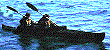
Maybe she was given a "helping hand" by someone like our intrepid cockleshell heroes,
as they did in
Snoopy's March 2015 Atlantic Attempt
.
Click on the kayak for more clues :-)
Does anyone have historical wind data for this area ? We may then know better what really happened !
Of course, we've used wind data here based on Carolina Dreamer's track to Borth.
Maybe she was given a "helping hand" by someone like our intrepid cockleshell heroes,
as they did in
Snoopy's March 2015 Atlantic Attempt
.
Click on the kayak for more clues :-)
Does anyone have historical wind data for this area ? We may then know better what really happened !
![]()
The picture below of Aberwystwyth Harbour is from Snoopy's pages, when we tracked John of Team-Joker collecting his boat. This is the base of Dai Jenkins of Aberwystwyth Marina. Dai's help on 5th February is mentioned on the Carolina Dreamer page ( as David Jenkins ). On 25th February, Dai and Robin spoke on the 'phone, and Dai was able to provide valuable information used here. e.g. The position reported to Dai on 5th February was at 52 27'N 4 16.2'W - but see doubts above. Dai also mentioned storm Imogen. More here soon, I hope. Does anyone have answers to some of those questions above ? :-)

![]()
![]()
There have been
visits to this page counted by
Digits Web Counter since 23rd February 2016.
How this is done is explained at the end of the
Snoopy page ;-)

© 1991-2016 Robin Lovelock. Please credit www.gpss.co.uk if you use material from any of these pages. Thankyou.