![]()
![]()
![]()
![]()
![]()
![]()
![]()
Home GPS Download Business Partners Contact Family AVL Links History AsOnTV
![]()
![]()
![]()
![]()
![]()
![]()
![]()
Home GPS Download Business Partners Contact Family AVL Links History AsOnTV

 This page explains how to import maps from
www.getmapping.com
into GPSS.
This page explains how to import maps from
www.getmapping.com
into GPSS.
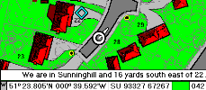
It is now possible for you to add mapping of your chosen areas within UK to a similar level of detail as I've had around Sunninghill for years - see picture on right. I don't know why we didn't set up this page earlier, since GPSS has now been popular within the UK for ten years, and Getmapping PLC have provided mapping from their website for years also.
 Free vector street mapping covering all
USA
has been available for over five years,
but recent changes to GPSS introduced to support free street level mapping for
Japan
as raster imagary have made adding mapping from Getmapping easier.
Most people adding street mapping of UK or western Europe into GPSS use
ARED from the Microsoft
AutoRoute
page. However, a few may wish to try the tips below, then consider purchase
of mapping from Getmapping.
Free vector street mapping covering all
USA
has been available for over five years,
but recent changes to GPSS introduced to support free street level mapping for
Japan
as raster imagary have made adding mapping from Getmapping easier.
Most people adding street mapping of UK or western Europe into GPSS use
ARED from the Microsoft
AutoRoute
page. However, a few may wish to try the tips below, then consider purchase
of mapping from Getmapping.
Robin Lovelock, Sunninghill UK, September 2005.

Start with steps 1,2 and 3 on the download page, and familiarize yourself with GPSS first.
If you add a map to GPSS as a small bitmap, such as a BMP image measuring only 231x231 pixels from www.getmapping.com then GPSS will automatically enlarge it to fit the screen. So, while you could add such maps without paying for them, the quality will not be anywhere near as good as those you purchase.
However, if you do purchase the higher quality image, as a 2000x2000 pixel image then GPSS will show the full detail and pan the image across the screen to follow the tracked car. I paid less than Ł25 by credit card transaction on their site and had the map in GPSS within minutes.
The steps to add a map into GPSS from getmapping.com are:
The picture on the right, reproduced here with the permission of Getmapping, shows you what to expect after entering SU933673.
You can get your six digit grid reference (e.g. SU933673) in many ways including from a paper Ordnance Survey map, your GPS or GPSS. Note that GPSS will normally display the UK grid to 10 digit (1 metre) accuracy. e.g. SU 93300 67300.
For a free, low quality sample image, you visit visit www.getmapping.com (Digital Aerial Photograph, Other Searches) and use the grid reference (e.g. SU933673) to choose your map. When it appears on the screen, hit the [Print Scrn] key to save the screen image into the Windows Clipboard. Then use any suitable image editor such as Paintshop Pro, Paint to crop out the 231x231 image and save it into the GPSS folder.
If you are buying the full quality image from Getmapping, you could order it as a JPG image to download. After doing your credit card transaction with Getmapping.com you will be emailed the URL. You then open this URL and save the image. e.g. XYZ123.JPG. Double click on this image to see it with Windows (e.g. the Fax and Picture Viewer) then use SAVE to save it as the required BMP image in the GPSS folder. e.g. SU933673.BMP
You must now calculate the south-west (low-left) and north-east (top-right)
corners of the image in GPSS format. For a 500x500 metre image (given where
you downloaded it from getmapping.com) you must subtract 250 then add 500.
e.g. from SU933673 you get:
SU 93050 67050
SU 93550 67550
You must then use something like Notepad to make a little text file with a suitable name (e.g. SU933673.DES) and with data dependent on if this is a 231x231 or 2000x2000 pixel image.
Here is an example of a 231x231 map file SU933673.DES:
Armitage from getmapping
SU933673
GG, 231, 231
SU 93050 67050, 0, 230
SU 93550 67550, 230, 0
GPSS.WAW
Here is an example of a 2000x2000 map file SU933673.DES:
Armitage from getmapping
SU933673
GG, 2000, 2000
SU 93050 67050, 0, 1999
SU 93550 67550, 1999, 0
GPSS.WAW
You can read more about DES files, if you need, on the addmaps page.
The above example was for just one of the scales of mapping available from Getmapping.com.
Other scales of mapping are available for pre-view then purchase from GetMapping. I checked out the 1:25,000 mapping: it was just as easy as the example above - but even less expensive - just Ł2.95 for the 1:25,000 sample which was 400x400 pixels (you would not want to use the "free image" approach above anyway, because the window has other information cluttering it).
I saved the purchased image as 22AC25.BMP and made this 22AC25.DES:
22 AC at 1:25k
22AC25
GG, 400, 400
SU 92800 66800, 0, 399
SU 93800 67800, 399, 0
GPSS.WAW
This 400x400 image is smaller than my screen resolution, so GPSS enlarges it to fit the screen.
I then used Paint inside Windows to enlarge the image 5x to 2000x2000 pixels so that GPSS could zoom in and pan around the map, following the car. I named the new image 22AC255.BMP and this was my 22AC255.DES:
22 AC at 1:25k 5x
22AC255
GG, 2000, 2000
SU 92800 66800, 0, 1999
SU 93800 67800, 1999, 0
GPSS.WAW